Whittier to Seward: Alaska's Coast
After spending a week in Girdwood, we had been looking ahead at places to go and due to there being no available campgrounds we were considering going straight to Seward or Cooper Landing. But I found a small place to pull off and camp situated right on a beautiful shimmering pond.
The next day, we packed up our gear and took our car towards Whittier to hike the Portage Pass Trail. The drive there was great, lots of mountains and glaciers popping up at every turn. Its a short drive, no more than 10 miles, but super fun. Before we could get to Whittier though, we were blocked by a giant mountain. The only way to pass was to go through the Anton Anderson Memorial Tunnel: 2.5 miles through the mountain, the longest highway tunnel in North America.
The tunnel is centered over the railroad tracks, meaning both cars and the Alaska Railroad go through the same path. Inside the tunnel, it is wet and cold, typical of the underground. It gave us all a collective chill to realize we were under millions of tons of rock. I don’t understand how people live and work underground. Gives me the shivers!
After emerging from the earth into the bright sunlight, we arrived at the trailhead for Portage Pass. The path quickly rose, winding along the shoulder of the mountain we had just crossed under. We hiked pretty fast, eager to see the glacier views.

The Anton Anderson Memorial Tunnel burrows through this imposing mass of rock on its way from Portage Lake.
At the top of the pass, though only 800 feet in elevation, the views were amazing. You could see back toward Whittier and the blue waters of Portage Canal, surrounded by steep green mountains. In the other direction, Portage Glacier slid down from its lofty beginnings among snowy, jagged peaks to rest in Portage Lake.

Overlooking Portage Canal and the town of Whittier.
From the top, the trail gradually descended toward the lake.

Shoutout to Osprey for the sponsored backpack!
Salmonberry bushes were plentiful, leading to some snack breaks.

At the edge of the lake the glacier views were simply fabulous. The lake was unusually calm, but frigid, the coldest water we encountered in Alaska (due to it basically melting right off the glacier). We spent some time skipping rocks and enjoying the views before heading back.

Portage Glacier melts directly into ice-cold Portage Lake.
The next day was spent relaxing and fishing for the abundant rainbow trout that live in the clear cold waters. They were almost too easy to catch!

Fishing for these lil trout was super fun and easy.
We headed south on the highway to the town of Seward. Amazing drive through the mountain valleys and down to the seashore.
The town of Seward is situated right on Resurrection Bay, with the campground taking up most of the waterfront. A paved path runs along the length of it, making for a fun bike ride (we took many in our stay there!).
In the small main street area, there are many cool food stores and art galleries. Our favorites were the Sea Bean Café (try their lemon-peanut sauce: so yummy!), Frontier Trading Post (they have incredible vegan/gluten-free donuts!), and Resurrect Art Coffee House, which is located in a beautiful old church building on the top of the hill.
We spent some time in the library, too, making use of the extensive book selection. The outside of the building is colored like the iridescent scales of a sea-bright salmon.
After several days enjoying the town, we drove back inland to visit Exit Glacier in Kenai Fjords National Park.
The glacier was an impressive sight, spilling out several miles from the Harding Icefield. Along the trail to the toe of the glacier we passed signs where the glacier had been in past years. At the entrance of the park was 1899 and the final viewpoint was only 2012. This showed the rapid melting of the glacier in recent years. I had seen pictures from last year that were different from when we arrived. The effects of climate change are so visible everywhere here.
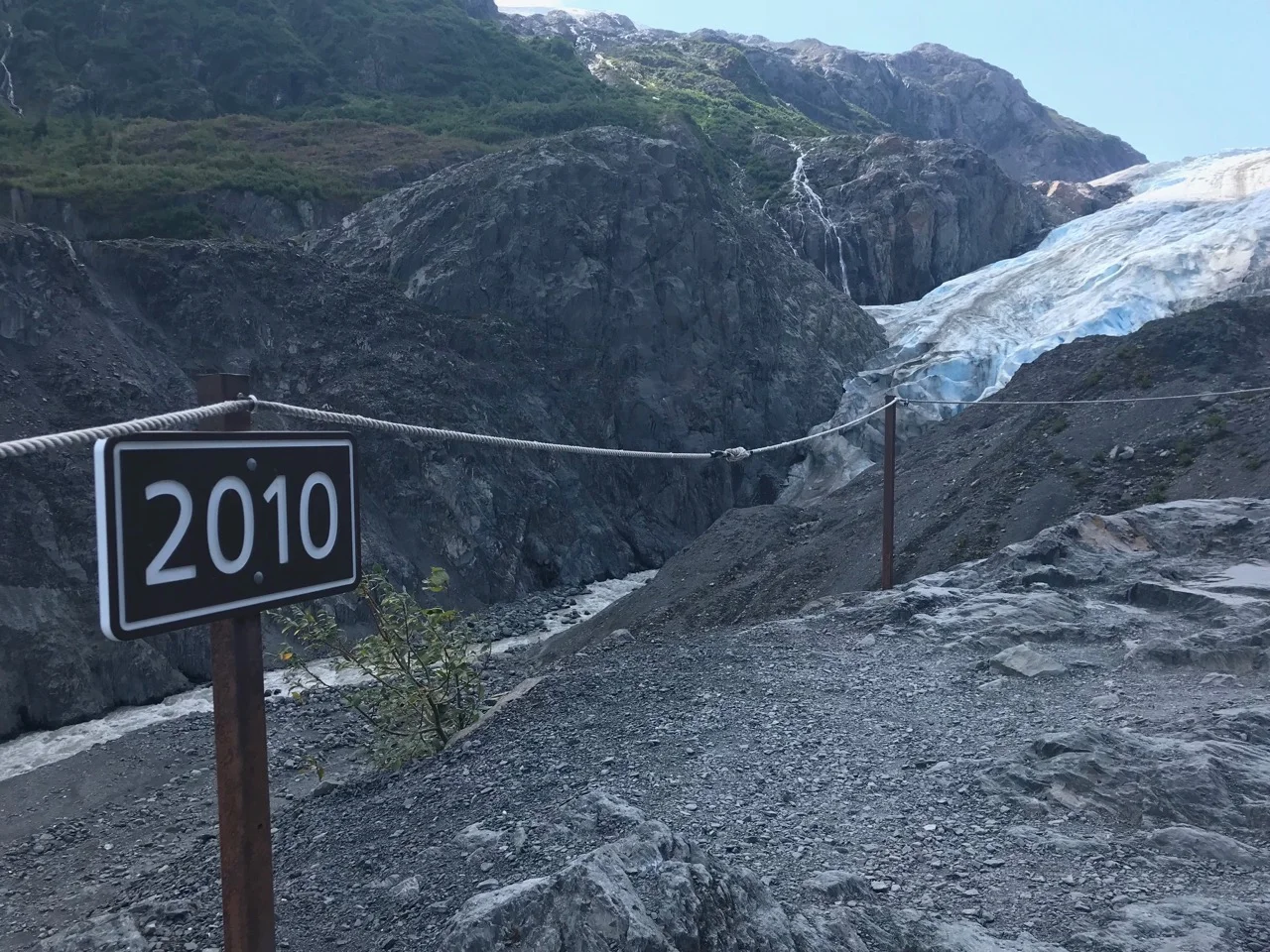
The toe of Exit Glacier has retreated way back from its former place in 2010.
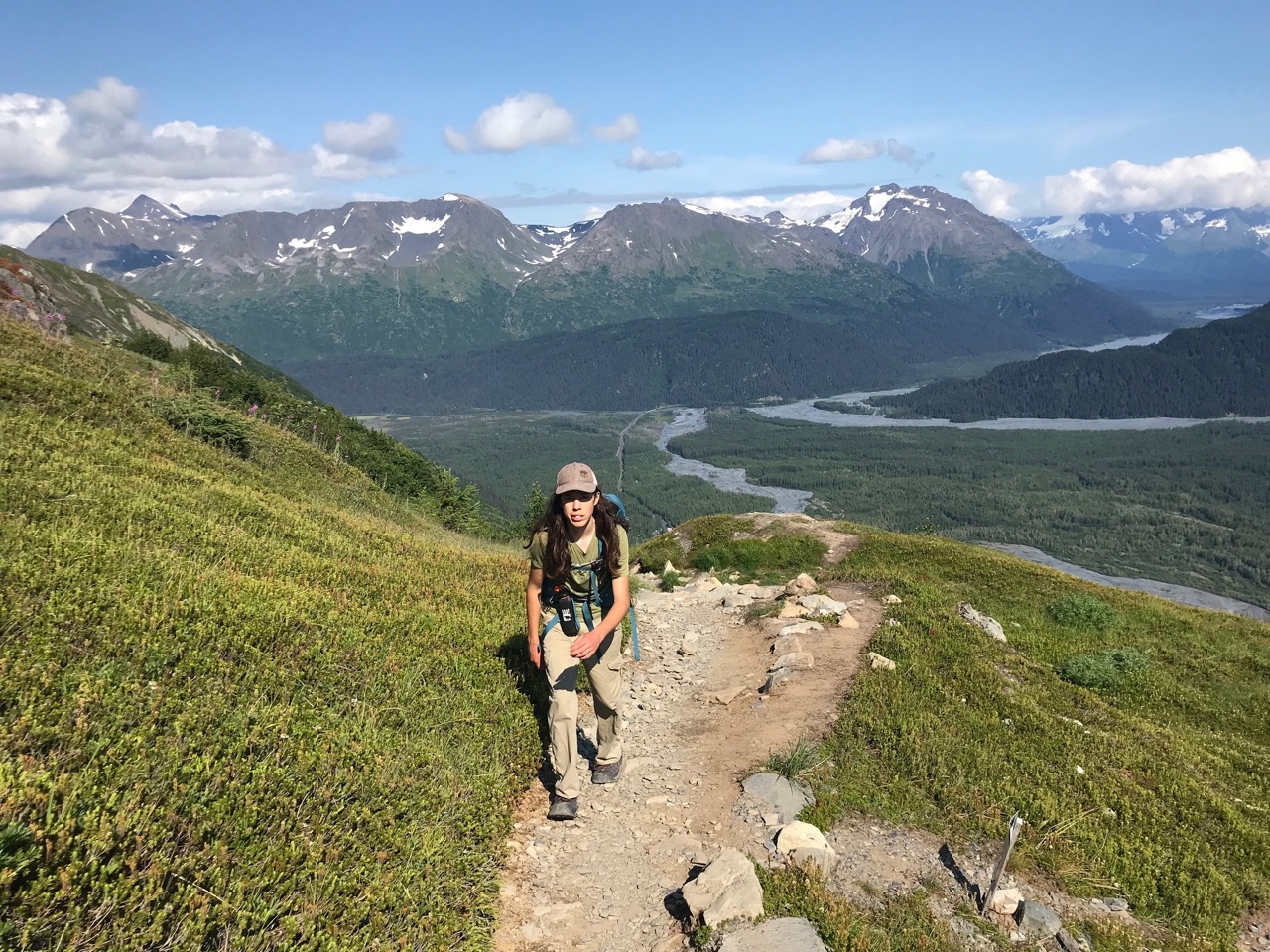
My brother Jack and I then decided to split off from the rest of the family and tackle the 8-mile Harding Icefield Trail- a 3,000 foot climb up to the edge of the 70-mile-long icefield.
After the first couple miles through lots of brush, the trail opened up to reveal stunning valley views.
Jack back on trail knocking out the miles!
Soon we ran into snow patches, including this harrowing snow bridge over a creek. The water had undercut the snow bank and was creating holes in the middle of the trail!

Snow bridges are crazy!
We kept heading to the top and the end of the trail ahead. We spotted mountain goats on the ridge, grazing in the short alpine grass.

This was an emergency cabin near the top of the trail. Empty inside, except for messages left over by visitors, we saw many from the 70s to 2019.
At the top, the icefield stretched away into the distance. Nunataks, the tops of huge rocky mountains, poked their jagged edges out of the white. The scenery felt unreal. Like, this is what most of North America looked like thousands of years ago? Crazy to think about. It is at once intimidating and intriguing.

We returned down the trail in the fading light, stopping occisonally to take it all in.

Exit Glacier in all its glory.
The next hike was totally different, but super cool too! We drove down to Lowell Point (which is further down the bay), on a bumpy gravel road with our pup, Spirit. It was his Birthday Hike! We intended to hike out to Tonsina Point, where there was a beach to chill at.
The trail wound through the coastal rainforest, full of moss and ferns. 1 mile in we came to a bridge over a small river, where you could look down on (chum) salmon swimming upriver. These fish were good-sized and in their spawning colors of red, black and green. They were packed together tight in the river, on their way to their spawning grounds.

This coastal creek was the spawning grounds for a lot of chum salmon and a great place to enjoy the views.
We relaxed on the beach, enjoying the views of the bay and Spirit’s doggy antics. At the end of the beach was a public use cabin, tucked away in the trees. We loved the idea of staying at a place you could only access on foot or by boat.

One of several public-use cabins on the trail, which extends 7 miles out to Caines Head.
As we were leaving, a bald eagle flew overhead and landed nearby right on the beach before taking off and flying back to the tree tops, with a fish in it’s claws! Everyone was excited and went into a photo-taking frenzy. We got some good shots in.

Bald Eagle captured mid-flight. These birds are incredibly photogenic.
The next day, we said goodbye to Seward and the oceanside and continued on our journey. We had just got word we would be able to go to Salmonfest, in Ninilchik, and we had a lot to do!
Cheers,
Connor